
3D Mapping Historic Sites with a Drone!
🛍️ Products Mentioned (3)
Ever wondered how drones are used to produce 3D models of historic sites? In this video I show you how this an be achieved through entry-level technology. With consumer grade equipment, and free-to-use software, it is a very simple process. www.diggingaustralia.com ________________________ Products: DJI Phantom 4 Pro V2: https://amzn.to/3fa4ccO DJI Mavic 2 Pro (excellent for its price): https://amzn.to/3fgm2uO ________________________ 00:00 - 00:50 Introduction 00:50 - 1:35 Setup 01:35 - 2:45 Why use a drone? 2:45 - 4:45 Metal detecting and drones 4:45 - 6:14 Capturing 3D Images 6:14 - 8:15 Processing the images 8:15 - 9:00 Final result ________________________ Instagram: https://instagram.com/digging_australia/ Facebook: https://www.facebook.com/DiggingAus/?ref=br_rs ________________________ How you can support the channel: Amazon Affiliate links By using these links Amazon passes on a small percentage of the sales to this channel (at no extra cost to you, it's basically an advertising fee) Airbnb Affiliate Link https://www.airbnb.com.au/associates/39396?s=67&c=.pi115.pk0_9&a4ptk=7415_0_9_39396&af=115 By using this link to book through Airbnb, the channel receives 30% of the Service Cost (paid by Airbnb, with no extra cost to you) And lastly, comment your thoughts, constructive criticism is always welcomed! ________________________ General questions/business enquiries: info@diggingaustralia.com Feel free to comment, like and subscribe! Thanks For Watching! Keywords: Drone pix4d pix4dcapture pix4ddiscovery mapping 3d mapping drone dji phantom 4 4k archaeology conservation preservation history historic heritage ww2 world war two reconstruction newcastle new south wales nsw australia australian history diggingaustralia digging australia WWII 1940s
🎬 More from Our Past

Operation Seagull: The Stockton Bight Disaster
20.7K views
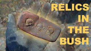
Abandoned Australian Mine Site Reveals Relics & Hidden Wells
1.7K views
Let’s see what’s hiding under the bridge 👀
781 views

Meet the Man Keeping Antique Clocks Ticking | Before it’s Gone Episode 6
869 views
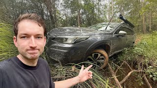
Everything Went Wrong | Searching for Gold Rush Settlements in Australia
5.4K views

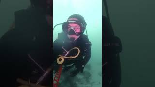
Exploring a WWII Shipwreck: The Ekkai Maru | Coron Bay, Philippines
784 views